
A Data Integration and Simplification Framework for Improving Site Planning and Building Design
IEEE Access, 2021
引用方式: Leng, S., Lin, J.R., Li, S.W., Hu, Z.Z.* (2021). A Data Integration and Simplification Framework for Improving Site Planning and Building Design. IEEE Access, 9, 148845-148861. doi: 10.1109/ACCESS.2021.3124010 http://doi.org/10.1109/ACCESS.2021.3124010
摘要
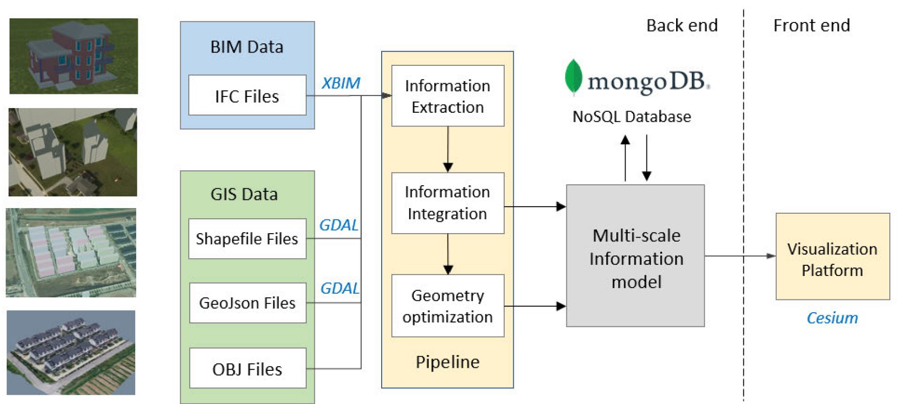
场地规划和建筑设计数据通常分散不同的地理信息系统 (GIS) 和建筑信息模型 (BIM)系统 中。数据多源异构为规划及设计数据的评估和交付带来了严峻挑战。针对该问题,本文提出了一种用于改进场地规划和建筑设计的数据集成和轻量化框架。研究提出了具有多尺度数据结构的BIM-GIS集成模型,实现了场地规划和建筑设计的数据的高效整合。同时,论文提出几何数据优化算法,可根据每个尺度所需的信息生成具有不同细节级别 (LOD) 的简化建筑模型。从而,研究建立了一套可行的方法来整合不同来源的规划和设计数据,实现场地规划与建筑设计的高效分析评估。在华东某村庄建设项目中的验证表明,该方法能够整合不同平台的场地规划和建筑设计结果,支持多尺度几何数据的无缝可视化,并为设计师、村民及政府部门沟通规划和设计成果提供了高效、直观的沟通环境,对服务乡村振兴具有重要意义。
Site planning and building design results are generally managed in Geographic Information System (GIS) and Building Information Modeling/Model (BIM) separately. The incompatibility of data has brought potential challenges for the assessment and delivery of the results. A data integration and simplification framework for improving site planning and building design is proposed in this paper. A BIM-GIS integrated model with a multi-scale data structure is developed to link the results of site planning and building design together. Geometric optimization algorithms are then designed to generate simplified building models with different levels of details (LODs) based on the information required at each scale. This paper provides a feasible way to integrate planning and design data from different sources to enhance the evaluation and delivery of the results. The proposed approach is validated by a village construction project in east China, and results show that the method is capable to integrate site planning and building design results from different platforms and support seamless visualization of multi-scale geometric data. It is also found that a seamless database facilitates understanding of planning and design results and improves communication efficiency. Currently, the main limitation of this paper is the limited access to 3D real-world data, and data collection techniques like point cloud are expected to solve the problem.
This work was supported in part by the National Key Research and Development Program of China under Grant 2018YFD1100900, and in part by the National Natural Science Foundation of China under Grant 51778336 and Grant 72091512.
Accession Number: WOS:000716675800001
ISSN: 2169-3536
IDS Number: WU6TN
发表评论